GIS Professional Services
Expertise from strategy and design to implementation and support.
GeoScope helps organizations harness location intelligence through consulting, data services, solution design, implementation, training, and managed GIS support.
Enterprise GIS Solutions
Powerful, integrated, intelligent GIS for the enterprise.
GeoScope delivers secure and scalable GIS environments that integrate systems, enable collaboration, analyze spatial patterns, and deploy flexibly across cloud, on-premises, or hybrid infrastructure.
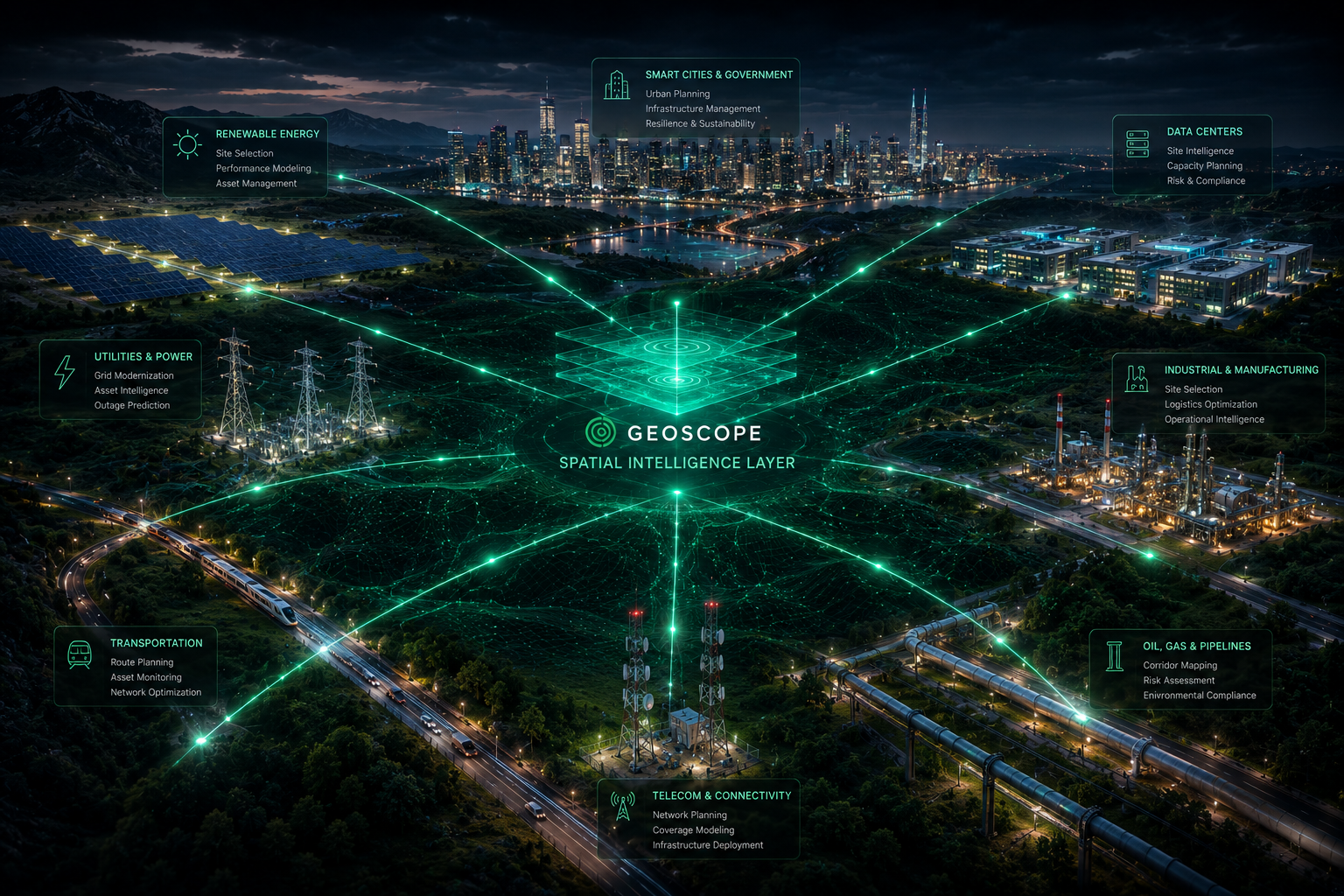
Services support government, utilities, energy, transportation, real estate, environment, insurance, telecom, and other industries where location intelligence improves operations.
ArcGIS Online / Enterprise
Data Pipelines
Spatial Analytics
Dashboards & Apps
Decision Intelligence
Comprehensive solutions
End-to-end value across data, analytics, assets, platforms, and business insight.
GeoScope's enterprise GIS work functions as a connected operating system for location intelligence.
Enterprise GIS Architecture
Design secure ArcGIS Online, Enterprise, cloud, hybrid, and governance patterns for mission-critical spatial operations.
Site Selection Intelligence
Build repeatable workflows for screening, suitability scoring, proximity analysis, market insight, and investment decisions.
Infrastructure Intelligence
Model utilities, energy corridors, fiber, assets, right-of-way, risk, and operational context around location decisions.
Spatial Data Engineering
Integrate, validate, clean, model, and automate spatial and non-spatial data pipelines teams can trust.
AI Geospatial Workflows
Apply machine learning, summarization, computer vision, predictive analytics, and automation to spatial decisions.
Dashboards & Decision Support
Create executive dashboards, custom apps, KPI reporting, story maps, and decision-ready visual products.
Visual systems
Image-backed GIS delivery areas with native fallbacks.
GeoScope service engagements connect enterprise architecture, data engineering, and infrastructure intelligence into one decision workflow.
Enterprise GIS
ArcGIS architecture, governance, and scalable platform delivery.

Data Pipelines
Spatial data engineering, validation, migration, and integration.
Infrastructure Intelligence
Energy, fiber, utility, and corridor context for decisions.
GIS Professional Services
Expertise from strategy and design to implementation and support.
GeoScope helps organizations harness location intelligence through scalable, high-quality GIS solutions tailored to specific business needs.
Engagements are designed to improve efficiency, enable better decisions, reduce risk, increase impact, and maximize GIS investment over time.
Strategize
Move spatial data into practical, scalable business workflows.
Design
Move spatial data into practical, scalable business workflows.
Implement
Move spatial data into practical, scalable business workflows.
Support
Move spatial data into practical, scalable business workflows.
Transform
Move spatial data into practical, scalable business workflows.
Professional services
Strategy, data, development, implementation, training, and managed support.
GeoScope's professional services cover the full lifecycle of GIS transformation.
Consulting and Strategy
GIS needs assessment, strategic roadmaps, platform evaluation, workflow automation, and use-case development.
Data Services
Data acquisition, conversion, migration, cleaning, validation, spatial database design, and management.
Solution Design and Development
Custom GIS applications, web GIS, mobile solutions, API development, third-party integrations, dashboards, and reporting.
Implementation Services
GIS platform implementation, system configuration, data integration, integrations, testing, and best-practice deployment.
Training and Capacity Building
End-user training, administrator training, custom workshops, documentation, and knowledge transfer.
Managed GIS Support
Help desk support, system monitoring, performance optimization, maintenance, updates, and long-term managed services.
Our Proven Approach
Discover, assess, design, deliver, optimize, and support.
GeoScope keeps professional services grounded in a clear lifecycle from current-state discovery through long-term support.
Discover
Validated delivery stage
Assess
Validated delivery stage
Design
Validated delivery stage
Deliver
Validated delivery stage
Optimize
Validated delivery stage
Support
Validated delivery stage
Outcomes
Measurable outcomes from professional GIS services.
The engagement model is designed to improve workflows, strengthen decisions, lower risk, increase impact, and maximize GIS investment.
Improved Efficiency
Better Decisions
Reduced Risk
Greater Impact
Higher ROI
Technology stack
Modern, scalable, intelligent, and powered by location intelligence.
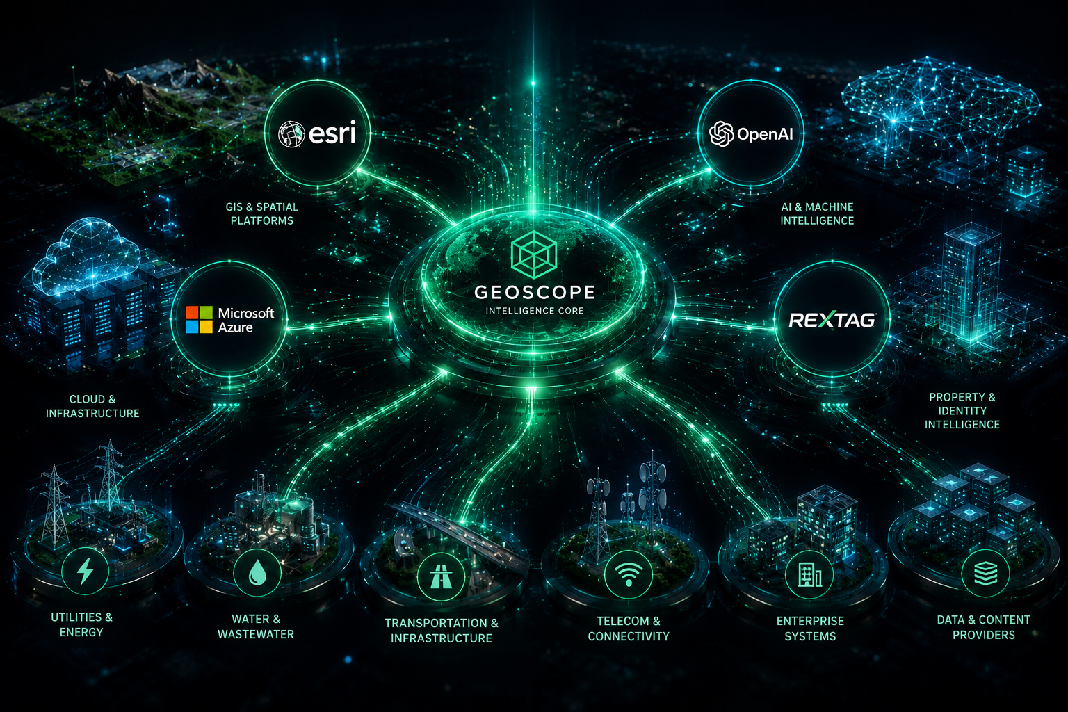
GeoScope's stack combines Esri technology, AI models, cloud infrastructure, integration tools, development frameworks, data standards, security, and governance.
Turn GIS capability into operational advantage.
Start with a services conversation around enterprise GIS, data integration, AI-powered analytics, or managed GIS support.