
Capability Statement
RFP-ready geospatial intelligence capabilities.
A modern capability statement based on GeoScope's 2025-2026 company profile, covering services, differentiators, markets, technology, process, and partner ecosystem.
Core capabilities
Full-stack geospatial intelligence from data to decisions.
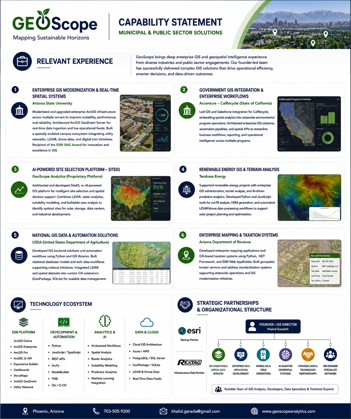
GeoScope delivers AI-powered site selection, enterprise GIS solutions, GIS professional services, OnePin building identity, and spatial analytics for complex location-based decisions.
200+
Curated data layers
500K+
Sites analyzed annually
25+
Industry sectors supported
99.9%+
Data quality assurance
Capabilities
What GeoScope can deliver.
Use this section as a procurement-friendly summary of GeoScope's services and technical delivery strengths.
AI-powered site selection
SiteIQ turns spatial data, AI, and proprietary data layers into actionable location intelligence.
Enterprise GIS solutions
ArcGIS-powered enterprise platforms for integration, analytics, collaboration, security, and deployment.
GIS professional services
Consulting, data services, custom GIS development, implementation, training, and managed support.
Spatial data analytics
Data integration, modeling, visualization, reporting, and quality-assured geospatial intelligence.
AI and automation
Machine learning, predictive analytics, pattern recognition, NLP, computer vision, and automated reporting.
Secure delivery
Enterprise-grade security, compliance, governance, cloud, hybrid, and on-premises deployment support.
Differentiators
Business-focused, trusted, secure, innovation-driven, and measurable.
GeoScope's profile emphasizes measurable impact, secure delivery, deep expertise, and long-term client partnership.
Business-focused solutions aligned with real operational goals
Trusted partnership built on integrity, transparency, and long-term success
Innovation driven by AI, data science, and advanced spatial analytics
Experienced geospatial professionals with deep domain and technical expertise
End-to-end capabilities from data acquisition to implementation and support
Proven results that improve efficiency, reduce cost, and enhance decision-making
Secure and compliant delivery with privacy and enterprise standards in mind
Global perspective with local insight for unique client challenges
Markets served
Location-critical industries with measurable impact.
GeoScope supports solar and renewable energy, data centers, urban planning, industrial development, utilities, energy infrastructure, and broader enterprise GIS needs.
Solar & Renewable Energy
Site screening, terrain analysis, environmental constraints, grid proximity, and feasibility scoring.
Data Centers & Digital Infrastructure
Power and fiber analysis, land evaluation, cooling and water access, risk assessment, and portfolio comparison.
Urban Planning & Government
Zoning, land use, transportation modeling, demographic analytics, infrastructure planning, and GIS modernization.
Industrial & Manufacturing
Industrial site selection, logistics corridors, utility access, environmental risk, and construction feasibility.
Utilities & Energy Infrastructure
Transmission and distribution planning, substation and corridor siting, reliability analysis, right-of-way, and asset management.
Enterprise GIS Programs
Data integration, cloud migration, dashboards, APIs, automation, training, and ongoing managed GIS support.
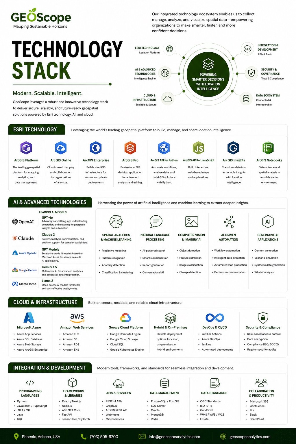
Technology stack
Esri, AI, cloud, integration, security, and standards.
The profile's stack combines ArcGIS, leading AI models, secure cloud infrastructure, modern development frameworks, data platforms, and geospatial standards.
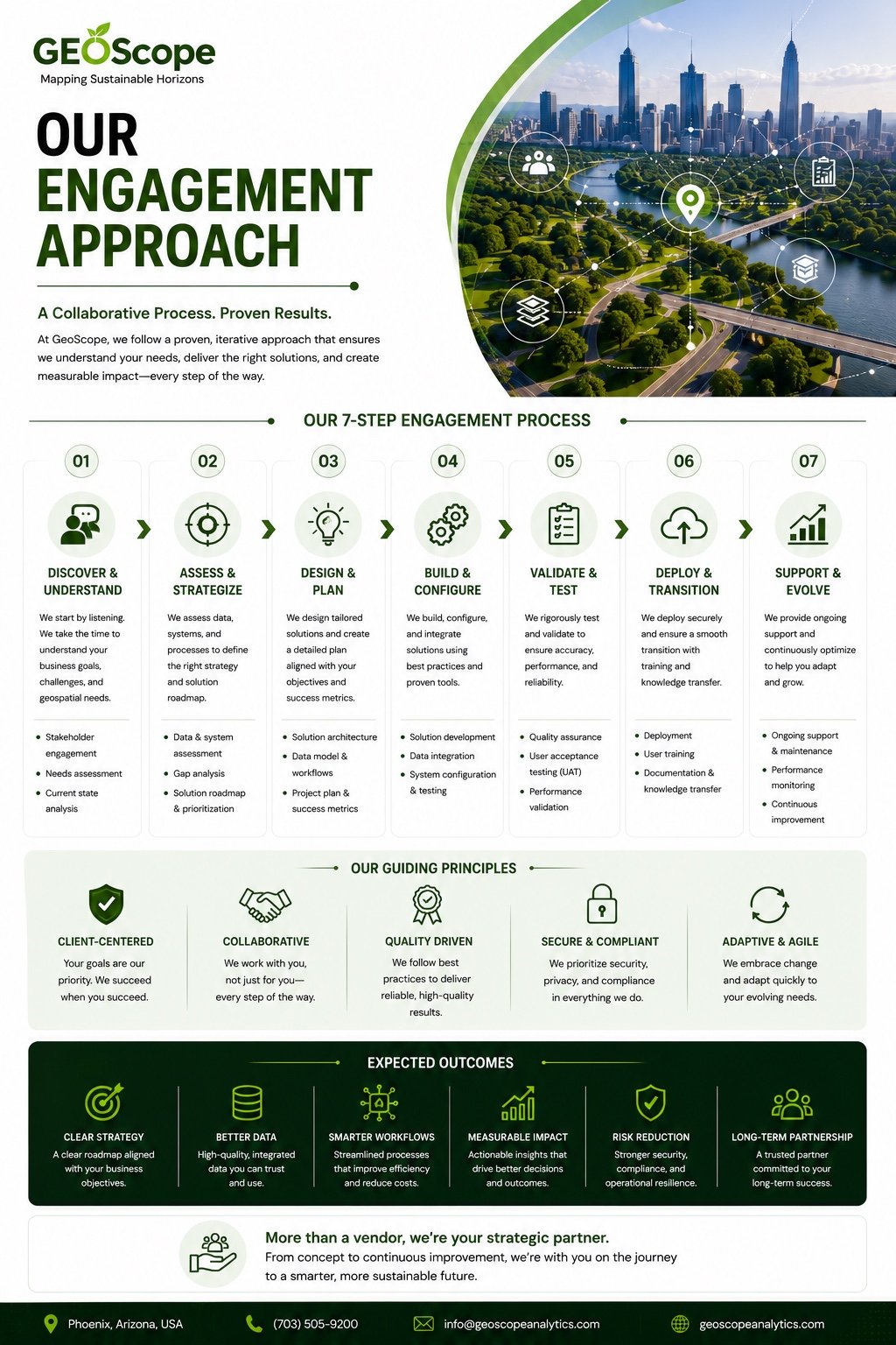
Engagement approach
A seven-step process from discovery to ongoing support.
GeoScope's engagement approach is client-centered, collaborative, quality-driven, secure, compliant, adaptive, and agile.
01
Discover and understand
Stakeholder engagement, needs assessment, current-state analysis, and clear definition of objectives.
02
Assess and strategize
Data and system assessment, gap analysis, prioritization, solution roadmap, and success metrics.
03
Design and plan
Solution architecture, data model, workflows, project planning, and implementation approach.
04
Build and configure
Solution development, data integration, system configuration, and best-practice implementation.
05
Validate and test
Quality assurance, user acceptance testing, performance validation, and reliability checks.
06
Deploy and transition
Secure deployment, user training, documentation, and knowledge transfer.
07
Support and evolve
Ongoing support, maintenance, performance monitoring, and continuous improvement.
Need RFP support materials?
Download the company profile or contact GeoScope for proposal-specific documents, capability attachments, and project-fit details.
Procurement resources
Capability materials for evaluation and RFP review.
Compact previews and downloadable materials help procurement teams evaluate GeoScope's geospatial capabilities quickly.
Capability Statement

Differentiators
Engagement
Technology